 First of all I want to apologize for the quality of these pictures. It was over cast all day, and I did not have time to edit any of them. I loaded them onto the hard drive straight from the memory card and re sized them for this blog. Any way, this is a shot coming down from my brief detour to the fossil bed.
 At the top of the thirty mile climb looking back. We came through that gap over there.
 It's hard to see, but this rock formation stood out like, like, well, like something weird.
 This was the sight I saw on my diversion on highway 19. Pretty cool huh?
 We rode through that narrow gap in Picture Canyon.
 Another shot from above the route on my way down from the detour.
 Green pastures in a dry desert like place. That's because they water the darn thing.
 I didn't make it to the fossil bed, so I took a picture of this instead.
 Everybody needs a break sometime. Today we met up with a bunch of young riders all headed to Florence. We had a group of 21 at one point.
 I really liked the way they worded this sign.
 At the grocery store picking up snacks and stuff before heading out.
 We ate dinner here at the Little Pine Cafe.
 I've never seen a tandem three wheeler recumbent before. Have you?
 Entering the town of Mitchell.
 We stopped to figure out how much further a 30 mile climb can be after 20 miles.
 You might have to click on this picture, but those are shoes hanging from this tree. hundreds of them.
 A deceiving deception. It looked like we were going down hill, but we were still climbing. I could tell because I was in my middle ring and when IO stopped pedaling, I quit moving forward.
 If you click on this image, you can see some of the amazing rock formations on the hill.
 The whole canyon was just plain awesome. i could have spent a whole day there just checking it out.
 Cars were very courteous when driving through these canyons. We never had a problem all day.
 The stream runs lazily along the bottom of the canyon as it makes it's way to the John
Day River.
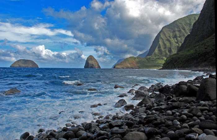
 You just got to be here to really appreciate the beauty of this place.
 I don't know what5 happened here, but it looked interesting to me, so I took it.
 A farmer harvesting his field. Looks like hay, but to me, everything looks like hay.
 More mid Oregon scenery.
 Leaving John Day this morning.
 Now this is cool. I took this shot as we were leaving John Day at a lumber plant. I think they were building a display or something.
Day 87, John Day to Mitchell, Oregon. “Cool Over Cast Day”. 72.02 miles. Total= 4,133.86 miles.
Thursday, August 6, 2009. The town of John Day would have been a great place to have spent a rest day. There are fossil beds in the surrounding area, and some of the neatest rock formations I have seen yet..
It was over cast this morning with the chance of thunder showers looming in the mist. It was very cool, bordering cold, and we dressed accordingly. After a healthy breakfast at a diner across the street from our motel, we were on our way. We stopped at a grocery store on the way out to pick up some snacks for the road since there would be no services today, other than the next town which was only seven miles away. The Adventure Cycling group showed up while we were inside, and we ended up riding together through out the day. The sun never came out once, and the road ahead looked like rain may be in store for us at one point. I do what I always do. I thank God for everything, good and bad, because I believe He is in control, and allows things to happen accordingly. Then I asked if He could hold back the rain. If it is within His Will that is, and left it at that. If it did rain, I was prepared. I did have my rain jacket handy, and I knew that at one point or another I would be riding in the rain. We’ve done so in the past, and although it was unpleasant, we survived.
I took a slight detour and decided to go up to this view point that over looked a fossil bed. I didn’t realize though that it would be quite a bit out of my way, and up a really steep climb. After a quarter of a mile or so, I gave up, it just wasn’t worth it at this point. Since I was up there, I took a few pictures of the valley below, and made my way back on route. Lisa had gone ahead since she wouldn’t know how long I would be gone. I followed our planned route, and entered Picture Canyon. This place is amazing. I was mesmerized. I found myself stopping at almost every turn to gaze in amazement and take pictures. I must have spend almost an hour just going the two and a half miles through there.
At the end of the canyon, the road forked. Highway 19 to the right, and our highway 26 route to the left. I was curious to see what was around the corner on 19. So I crossed the bridge, and rode on just so I could get a glimpse of what was on the other side. There was an Information Center describing the fossil beds, and a great view of some of the rock formations this place is known for. I then turned around to go back, where I met Chris. One of the Adventure Cycling riders who we have been seeing on a regular basis for the past couple of weeks. We stopped and talked a while and took more pictures. I we then decided to ride together, since I didn’t have a map, and didn’t know where the hell I was going. As we rode along, I stopped occasionally to take more pictures, Even though the sun was not out, the scenery was just too good to pass up. Almost immediately, the 30 mile climb we’ve heard about began. A gradual climb, so not like we were killing ourselves. And the cool temperature almost made it a piece of cake, if there is such a thing.
The rest of the day was spent climbing. We were averaging between 5 to 6 miles an hour, so it took some time to reach the top. But let me tell you, once there, it was “Hold on to the handle bars and don’t blink!” for the next seven miles. Lisa was waiting for me at the entrance to Mitchell. The town we would be staying at tonight. Mitchell is a small town with a population of only 160. This means one store, one gas station, one hotel, and one bar.
Tonight we are staying at “The Oregon Hotel” in down town Mitchell. It’s an old rustic wooden structure with charming accents. A real nice place. Tomorrow our destination is Redman. About 70 miles from here. Thank you all for your continual support. We are almost there, and can not wait to be back home again. Aloha, Ted.

No comments:
Post a Comment